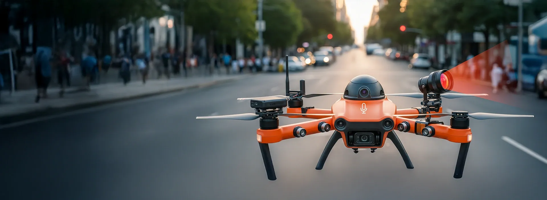
Drones are no longer just flying cameras, as they've become strategic assets for enterprises that gather, analyze, and act on visual data at scale. When powered by computer vision (CV), drones can detect anomalies, track objects, map complex environments, and even navigate autonomously. The result? Operations that are faster, safer, and more data-driven than ever.
Computer vision development services help businesses transform raw aerial data into actionable intelligence. From predictive maintenance and infrastructure monitoring to precision agriculture and safety operations, it is possible to integrate AI-driven vision systems into drones to deliver measurable business value.
In this guide, we'll discover how computer vision enhances drones, explore real-world applications, and reveal the technology behind high-impact results.
Understanding computer vision
Computer vision has moved from research labs into boardroom discussions. As enterprises collect more visual data from cameras, drones, and IoT sensors, they're creating new ways to see and understand the physical world. Computer vision is a field of computer science focused on developing algorithms that allow computers to "see", extract, interpret, and act on visual information much like humans do, but at an enterprise scale. It combines cameras and sensors with deep learning algorithms that recognize patterns, objects, and environmental changes in real time.
From a technical perspective, three key layers make this possible:
- Data capture: Cameras, LiDAR, and thermal sensors record detailed visual and spatial information from the environment.
- Machine learning models: Neural networks (CNNs or transformers) process images and video to detect, classify, and segment objects or features.
- Actionable output: Insights are delivered into enterprise systems, where they inform decisions.
When paired with drones, computer vision turns aerial imagery into business intelligence, enabling data-driven operations across industries.
Compare machine vision and computer vision—choose the right technology for your needs!
Success!
Discover how to implement computer vision: A practical guide for enterprises.
How computer vision powers drones
Drones enhanced with computer vision are intelligent systems capable of interpreting their surroundings, making decisions in real time, and operating safely at scale. Instead of acting as remote-controlled cameras, they become autonomous platforms that understand context, recognize patterns, and react instantly to what they detect.
This capability is possible only when advanced imaging hardware, edge computing, and AI-driven algorithms work together mid-flight, turning raw visual data into actions, insights, and safe navigation. As a result, drones advanced from simple data collectors into high-value tools for inspection, monitoring, mapping, and decision support across industries.
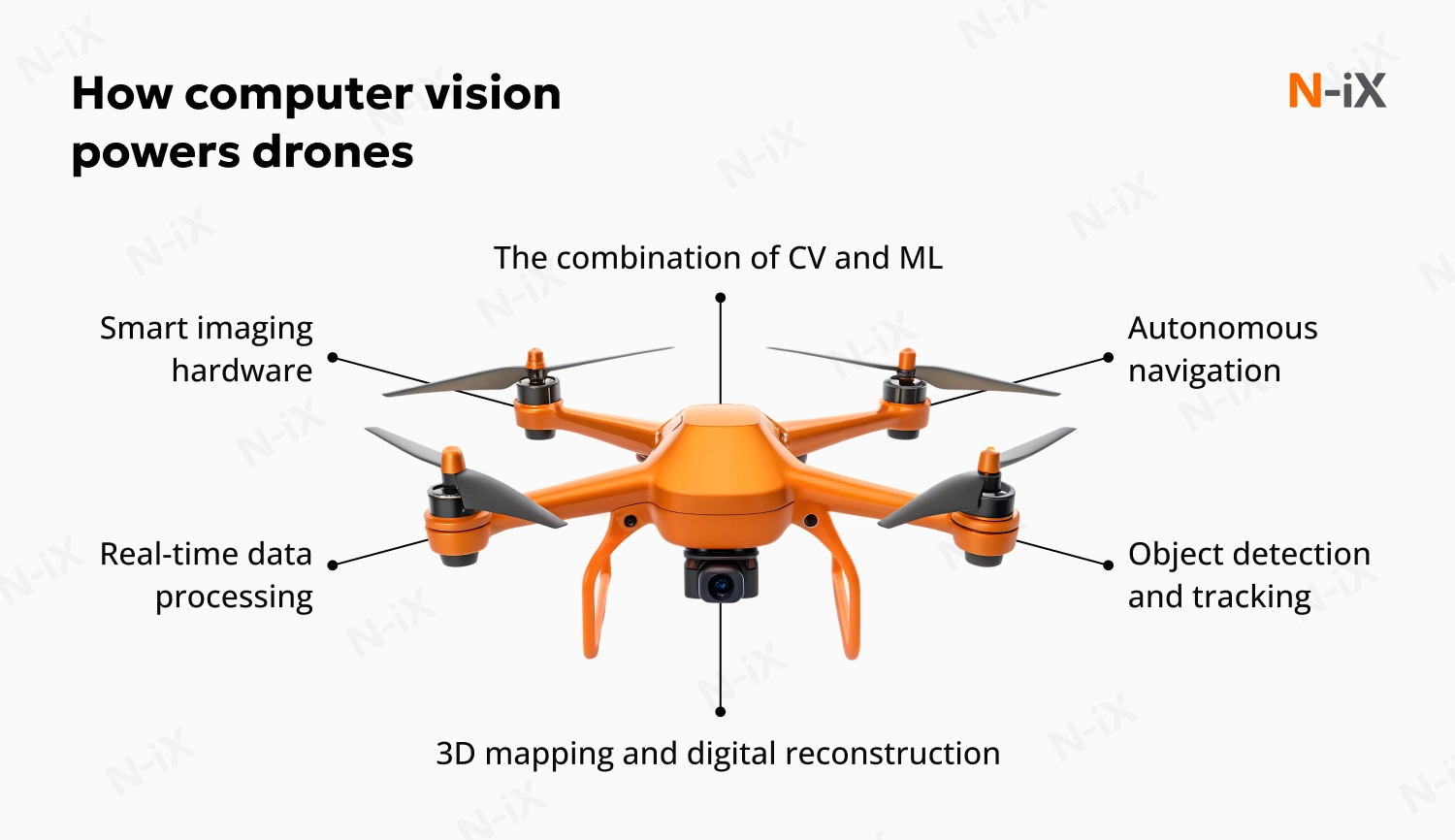
Smart imaging hardware
Modern AI-powered drones combine high-resolution optical cameras, thermal imaging, and LiDAR or depth sensors to capture accurate visual and spatial data. This multimodal input enables the system to detect fine-grained defects, measure 3D structures, navigate in low-visibility conditions, and classify terrain. High-quality raw data is the foundation for every downstream computer vision capability.
Richer, cleaner data means fewer repeat flights, more accurate inspections, and faster decision-making, reducing operational costs and minimizing downtime across construction, energy, agriculture, and logistics.
Autonomous navigation
One of the most advanced applications of drones with computer vision is autonomous flight. They analyze the environment, detect obstacles, estimate distances, and adjust their flight path in real time. This enables safe operation in mines, forests, urban areas, and other high-risk locations where GPS is unreliable. This creates new operational possibilities:
- Search and rescue: identifying people or hazards in dynamic, hard-to-reach areas.
- Urban inspections: safely maneuvering around buildings and power lines
- Forestry and agriculture: mapping terrain while avoiding obstacles.
Autonomous navigation enables missions that are too dangerous, slow, or expensive for human crews, reducing risk exposure and enabling 24/7 inspections or monitoring.
Object detection and tracking
Computer vision models trained on drone-specific datasets enable drones to detect and classify objects ranging from people and vehicles to infrastructure components and environmental features. Using convolutional neural networks (CNNs), AI-powered drones can automatically detect, classify, and track:
- Vehicles, people, power lines, or damaged assets
- Hotspots on energy infrastructure for predictive maintenance
- Parcels or barcodes in warehouses
- Crop diseases or pest infestations in agriculture
Accurate detection and tracking turn raw imagery into actionable insights, helping teams prioritize repairs, prevent failures, automate warehouse workflows, and respond earlier to risks.
Real-time data processing
The real impact of an AI drone depends on how quickly it processes data. With edge computing, drone computer vision can analyze visual data onboard without relying on cloud connectivity, delivering:
- Real-time obstacle avoidance and path planning even in dynamic environments
- Instant anomaly detection during inspections (corrosion, cracks, hotspots, misalignments)
- Faster response in emergencies, with models analyzing data mid-flight
- Secure operations, such as detecting unauthorized drones or airspace threats
- Operational efficiency, as drones assess construction sites, energy infrastructure, crops, or logistics routes without waiting for cloud round-trips
Technologies like OpenCV remain central to this: they handle low-level image and video processing, stabilization, feature extraction, motion tracking, and spatial analysis. Combined with deep learning, on-board processing enables drones to react in milliseconds, which is important for industrial, public-safety, and defense applications.
3D mapping and digital reconstruction
Computer vision automates the entire pipeline from image capture to feature extraction to building accurate digital twins. This helps enterprises transition from reactive maintenance to predictive, data-driven decision-making. With photogrammetry and LiDAR, drones create detailed 3D models of landscapes, infrastructure, and urban environments. These models support:
- construction progress tracking
- structural health assessments
- environmental monitoring
- urban planning and zoning
- mining volume calculations
High-fidelity 3D models improve planning accuracy, reduce rework, and help organizations shift from reactive to predictive maintenance, saving significant time and budget.
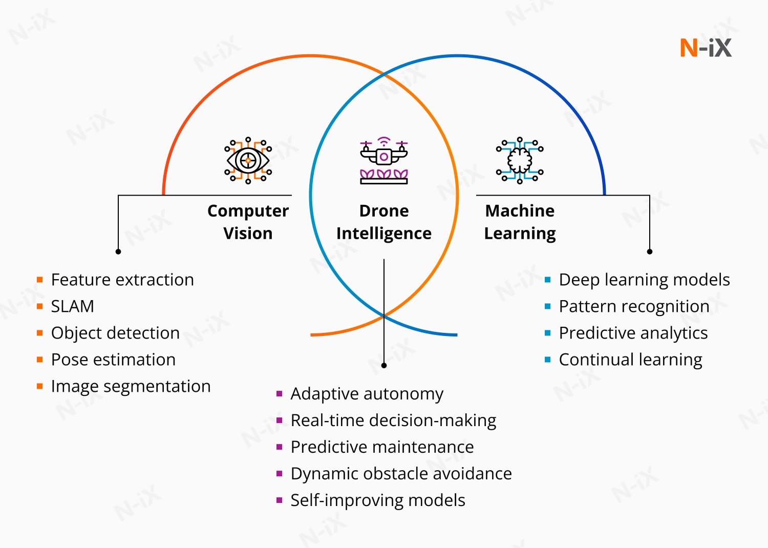
The combination of CV and ML
The real power of drone systems emerges when computer vision and machine learning operate together. ML models learn from large datasets, improving their ability to classify, segment, and predict. Computer vision interprets real-time scenes and feeds these models the context they need to act. This synergy enables AI-powered drones to:
- adapt to new environments
- improve accuracy over time
- handle complex missions autonomously
- deliver high-quality insights at enterprise scale
Together, these technologies turn drones into fully autonomous inspection, monitoring, and decision-support systems. Their real impact, however, depends on how well they are engineered and integrated into enterprise workflows, a factor that ultimately shapes the business value companies can achieve.
Business value: Why enterprises invest in drone computer vision
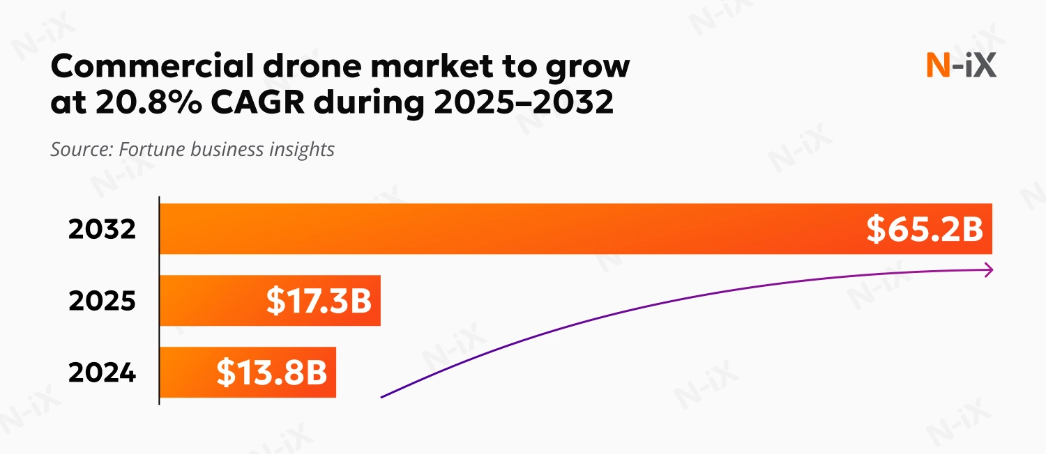
The AI-powered drone market is projected to grow from 20.2 B in 2025 to over 61.6B by 2032. Enterprises investing in computer vision drones today are tapping into a technology that will be central to operational intelligence across industries, from energy to agriculture.
|
Business impact |
Executive value |
|
Operational agility |
Reduce manual inspections, optimize schedules, and cut downtime. |
|
Cost optimization |
Lower labor, travel, and equipment costs with automated visual analytics. |
|
Safety and compliance |
Minimize human exposure to dangerous environments. |
|
Sustainability and ESG goals |
Replace fuel-intensive inspections and reduce the environmental footprint. |
|
Data-driven decisions |
Integrate drone-captured intelligence into predictive analytics and digital twins. |
Enterprise use cases of computer vision drones
Construction and infrastructure: Faster oversight, fewer risks
Drones with computer vision bring immediate visibility into construction and infrastructure, allowing enterprises to replace slow, manual reporting with continuous, high-fidelity site intelligence. Instead of relying on fragmented updates from field teams, you get a real-time view of progress, structural integrity, and compliance. CV models process drone-captured imagery to highlight deviations from design, early signs of quality issues, or unsafe areas, long before they impact timelines or budgets. This closes the information gap that often causes delays, cost overruns, and safety risks.
Modern construction companies integrate drone feeds with their project management and BIM environments, creating unified dashboards that tie aerial insights directly to work packages, schedules, and resource plans. For example, a vision-based system from ETH Zurich enables fully autonomous power line tracking without prior infrastructure data, using real-time perception and trajectory planning.
CV-driven tasks include:
- Comparing actual site progress against digital plans
- Detecting structural defects, cracks, or misalignments
- Identifying safety violations or hazardous zones
- Monitoring earthworks, excavation volumes, and equipment movement
Energy and utilities: Smarter asset monitoring
For energy and utility providers, maintaining large distributed infrastructures: power lines, wind turbines, substations, pipelines, is one of the largest operational challenges. Drones' computer vision makes this work faster, safer, and far more proactive by capturing and analyzing visual data continuously, rather than only during scheduled inspections. CV models detect corrosion, vegetation encroachment, loose fittings, hotspots, insulation damage, or mechanical wear with a level of precision that human visual checks can't consistently achieve.
Utility companies integrate drone intelligence into their asset management systems to prioritize repairs, automate work orders, and reduce outage risks. Instead of sending crews to remote or hazardous locations, they use autonomous or semi-autonomous drones that can navigate along lines or over uneven terrain. Real-time anomaly detection helps operators act before faults escalate into disruptions. This shift from manual inspections to AI-assisted monitoring results in fewer emergency outages, longer asset life cycles, and substantially lower maintenance costs.
CV-enabled insights include:
- Detection of hotspots using thermal imaging
- Vegetation mapping for predictive trimming
- Identifying worn insulators, connectors, or conductor damage
- Monitoring pipeline coatings and detecting early corrosion
Agriculture: Turning visual data into better yields
Beyond capturing large-scale field data, computer vision drones analyze plant health, moisture distribution, disease patterns, and soil variation in real time. This allows farmers to detect issues weeks earlier than visual field scouting, respond with precision treatments, and reduce wasted inputs.
Across the industry, drone technology is already proving its value. Some systems classify seed quality with up to 99% accuracy, while others map stress indicators that are invisible to the human eye. Reforestation initiatives offer strong examples of this progress: companies such as DroneSeed deploy heavy-lift CV-guided drones to restore wildfire-damaged terrain, and BioCarbon Engineering enhances aerial surveys and precision seed placement with machine learning to optimize regrowth over time. These same capabilities, precise mapping, object detection, and adaptive flight, translate directly into smarter, more scalable agricultural operations.
AI-guided drone tasks include:
- Early detection of diseases or pest infestations
- Vegetation index (NDVI/NDRE) analysis for crop health
- Soil and moisture mapping for irrigation optimization
- Tracking plant emergence and growth patterns
Read more about computer vision in agriculture
Public safety and security: Faster situational awareness
Computer vision drones deliver situational awareness that ground teams cannot achieve on their own. During emergencies, large events, or environmental hazards, drones provide real-time aerial feeds, detect movement patterns, locate people in need, map dangerous areas, and monitor restricted zones.
Emergency services and security organizations integrate drone video into command centers, where AI helps highlight anomalies, identify hazards, track crowd density, or detect unauthorized activity in critical areas. This reduces the time it takes to make informed decisions, improving both response speed and operational safety. Whether used for search and rescue, wildfire tracking, or monitoring airports and industrial sites, CV-driven drones serve as real-time intelligence systems that enhance coordination and reduce human risk.
Example CV capabilities:
- Identifying people or vehicles in low-visibility conditions
- Mapping hazardous areas during fires, floods, or chemical incidents
- Monitoring critical infrastructure and restricted zones
- Tracking crowd flow and detecting unsafe patterns
Logistics and warehousing: Cleaner inventory, faster fulfillment
In logistics, computer vision drones are redefining how warehouses track, audit, and move inventory. Instead of relying on slow, labor-intensive cycles or manual scanning, CV-enabled drones navigate narrow aisles, read barcodes or RFID tags, and deliver real-time visibility into stock levels. The result is fewer miscounts, faster order fulfillment, and a more resilient supply chain.
Warehouse drones operate autonomously in GPS-denied indoor environments using vision navigation and SLAM. They integrate directly with WMS and robotics platforms, feeding a continuous stream of accurate inventory data into enterprise systems. Companies like IKEA, Geodis, Walmart, and Amazon have already integrated drone-based inventory scanning into their warehouse workflows, reporting reductions in cycle count from weeks to hours, improved safety, and cleaner inventory records that strengthen downstream processes such as picking, replenishment, and reverse logistics.
What CV-powered drones enable in logistics:
- Automated cycle counting without halting operations
- Rapid location of misplaced items, reducing fulfillment delays
- Compliance checks for regulated goods (pharma, food, electronics)
- Real-time warehouse mapping for layout optimization
- Safer inspections of high racks, HVAC systems, and lighting
- High-fidelity data supporting just-in-time replenishment and better demand forecasting
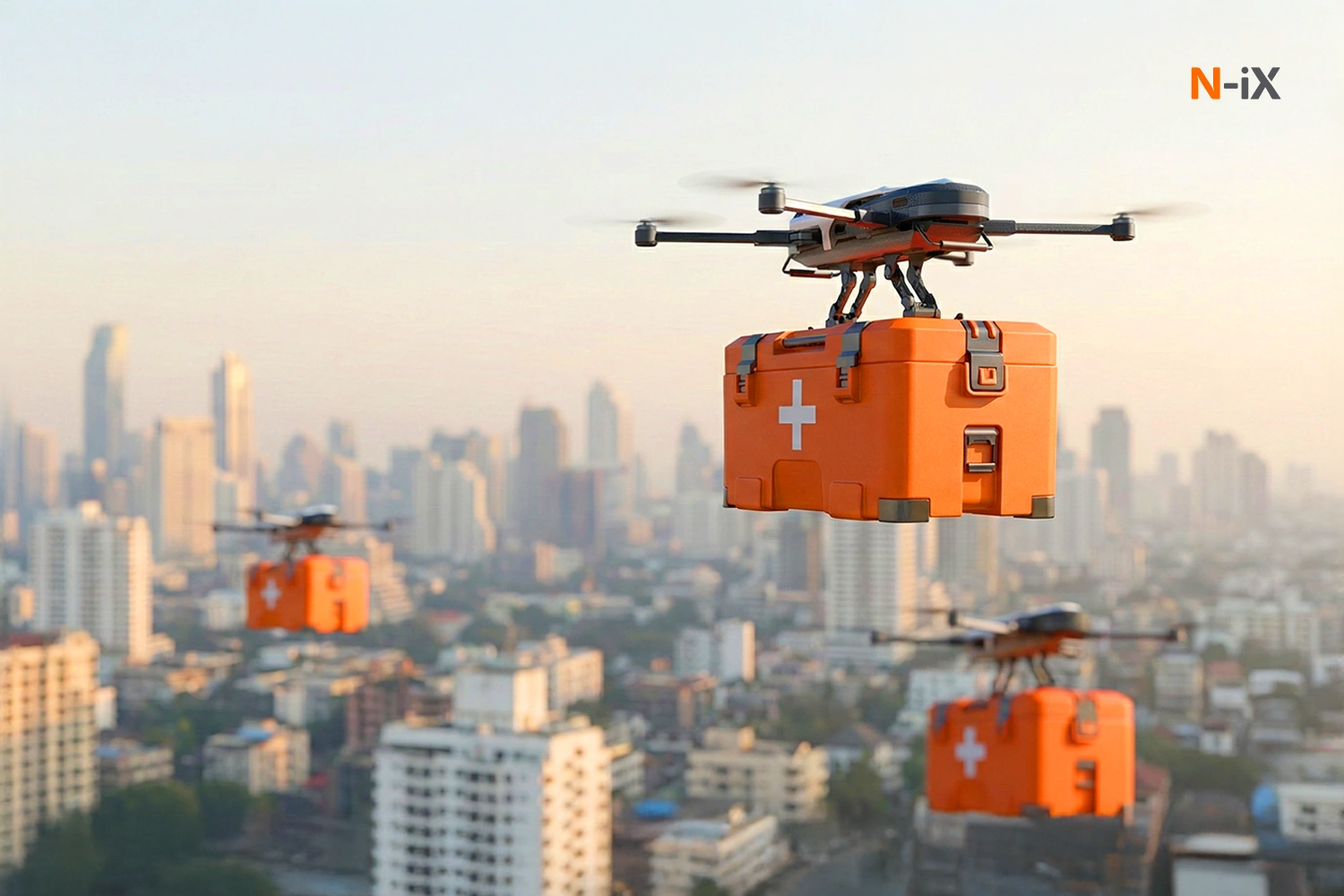
Healthcare: Shift in medical logistics
Over the past decade, drones with computer vision have transitioned from limited experiments, delivering blood to remote clinics or flying COVID test kits to central labs, into scalable operational services that save lives and enhance health equity.
Medical drones enable a faster, more reliable healthcare supply chain delivering life-saving biologics, emergency equipment, and diagnostic samples where traditional transport struggles. Their ability to bypass traffic, rough terrain, and infrastructure gaps accelerates the delivery of critical cargo, including blood products, vaccines requiring cold storage, and portable medical devices. MissionGO (USA) successfully demonstrated the delivery of a donor kidney via drone, proving the feasibility of integrating autonomous drones into regulated transplant systems. Historic breakthrough in expanding usable donor pools by improving organ viability.
Key use cases of drone computer vision in healthcare:
- Organ transport (kidneys, tissues) for transplant operations
- Emergency medical supply delivery to remote and disaster areas
- Lab sample transport (blood, tissue, genomic tests) for diagnostic turnaround time reduction
- Point-of-care diagnostics (portable ultrasound, PCR devices delivered by drone)
- Telemedicine integration with onboard cameras and communication hardware
Technical and strategic challenges and N-iX solutions
Scaling drone computer vision across an enterprise isn't just about technology adoption; it's about building a data, AI, and integration ecosystem that can support it. Below are the most common challenges executives face, and how N-iX turns them into advantages.
Data management and scalability
Drones generate enormous amounts of visual data: high-resolution images, LiDAR scans, and video streams that quickly add up to terabytes. Managing, labeling, and processing this data efficiently while keeping it secure is a major operational burden.
N-iX solution: We design end-to-end cloud data pipelines that automate the ingestion, storage, and processing of visual datasets. Our data engineers build scalable architecture, enabling enterprises to easily train and deploy computer vision models while maintaining strong data governance and security standards.
Model accuracy
As CV models are trained in controlled environments, they often underperform in real-world conditions, where changes in lighting, weather, or terrain can affect accuracy.
N-iX solution: Our AI experts use data augmentation, model retraining, and continuous learning pipelines to adapt vision models to diverse environments. With advanced MLOps practices, we help clients monitor model drift, maintain accuracy, and achieve consistent performance across locations and climates.
Integration with enterprise systems
Drone data has little value if it stays isolated. Integrating drone insights into enterprise systems like ERP, EAM, or GIS platforms is often complex and resource-intensive.
N-iX solution: We integrate AI-powered drone intelligence into existing enterprise ecosystems. From API design and middleware development to cloud-native integration, we ensure drone-collected data flows seamlessly into your operational and decision-making platforms, enabling real-time visibility across the organization.
Battery life and connectivity limitations
Limited battery capacity and unstable connectivity make it challenging to perform long-duration missions or transmit data in real time, especially in remote locations.
N-iX solution: We optimize data processing using edge AI architectures, enabling drones to analyze imagery locally and send only essential insights to the cloud. This reduces transmission demands and extends operational time. Our engineers also design lightweight AI models optimized for on-device inference, ensuring reliability even in low-connectivity environments.
Regulatory compliance and data security
Enterprises operating drones across different regions face strict regulations, from airspace restrictions to GDPR-like data privacy laws. Non-compliance can lead to project delays or penalties.
N-iX solution: Our team assists enterprises in building compliant architectures and secure AI workflows that adhere to both aviation and data protection standards. Our engineers implement encryption, access controls, and audit trails across the entire AI lifecycle, helping clients scale globally while maintaining full regulatory compliance.
Discover more: Computer vision in agriculture: A complete guide
Final note
Computer vision isn't just about capturing images. It's about turning visual data into actionable insights, and AI plays a crucial role in this process. AI-powered systems interpret patterns, detect anomalies, and enable real-time, data-driven decisions, making computer vision a powerful tool for businesses.
The most impactful use cases address high-value business challenges, but technology alone isn't enough. Enterprises need a tech partner to implement AI-powered systems effectively, integrate them with existing operations, and ensure they deliver measurable results. That's where N-iX excels. We combine deep expertise in computer vision with industrial-grade AI solutions, helping organizations to benefit from drone intelligence and achieve their business goals.
With over 23 years of experience in the market, we've delivered more than 60 successful data science and AI projects. Our team brings together 200 data, AI, and ML experts, supported by a strong engineering team, to deliver reliable, scalable, and enterprise-grade solutions.

Have a question?
Speak to an expert